Pages

Showing posts with label Oceans. Show all posts

November 25, 2010

From the World of Unintended Consequences

FROM-The State

Global warming fix could threaten food chain


Researchers say plan could jeopardize oceans by introducing toxins into the food chain
By SAMMY FRETWELL


An experimental plan to fight global warming could cause blooms of poisonous algae in seafood-rich stretches of the open ocean, say researchers at the University of South Carolina.

For more than 20 years, scientists have discussed whether adding iron to the sea could effectively keep carbon dioxide out of the atmosphere by causing the increased growth of phytoplankton, a tiny ocean plant that absorbs the greenhouse gas from air.

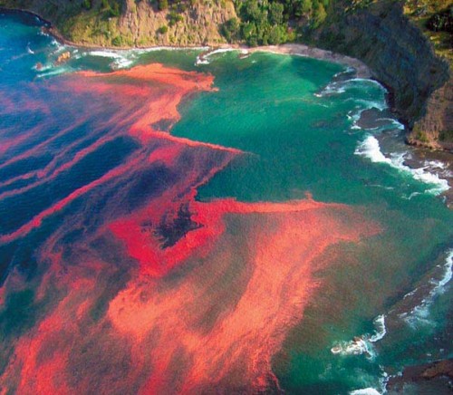
But recent research shows that putting more iron in the ocean also could cause an explosion in growth of toxic algae.

A recent report by researchers from USC, the University of California-Santa Cruz and LSU says they have documented the toxic algae in sections of the open Pacific Ocean, a finding believed to be the first of its kind. Previously, the toxin had been known almost exclusively along the immediate coast, near beaches and harbors.

South Carolina professor Claudia Benitez-Nelson, a member of the research team, said adding iron to the sea might help curb global warming — but not without a potentially caustic side effect.

“This study has shown that when you add nutrients to the ocean, sometimes you have organisms grow that are really bad for you,’’ Benitez-Nelson said.

While many species harvested for seafood come from near shore waters, others can be found in the deep ocean. Anchovies, for instance, are harvested well out to sea off the coast of Mexico, Central America and California.

The concept of adding iron to the ocean dates to at least 1990. The idea is that since iron stimulates plant growth, ocean plants, which use carbon dioxide, could draw it into the sea, rather than let it rise into the atmosphere. Carbon dioxide in the atmosphere helps to trap heat, which causes earth’s temperatures to rise.

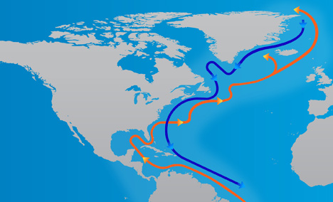
The research paper, published recently in the Proceedings of the National Academy of Sciences, is one of the first to look at algae blooms far offshore. Much of the field work was done hundreds of miles out at sea, and included areas off South America and Antarctica where iron has been introduced as an experiment.

“This is one of the first studies to convincingly prove one of the detrimental impacts of marine iron addition,” Benitez-Nelson said. “It shows that one solution you think may work, in the long term, it may even be worse than your original problem.’’

Carolina researcher Emily Sekula-Wood joined Benitez-Nelson on the team of scientists. The research was headed by Santa Cruz professor Mary Silver.

Benitez-Nelson said putting iron in the ocean raises ethical questions about “tinkering with mother nature.’’ Adding iron on a large scale could prove dangerous if the neurotoxins get into the food chain, the research team said.

The algae of concern is pseudo-nitschia, which produces a toxin called domoic acid. The toxin can make sea life sick.

In the past, the toxin has gotten into the food chain in coastal waters near shore, poisoning shellfish and other seafood. People eating seafood containing the toxin can get upset stomachs, suffer memory loss and become dizzy. In extreme cases, people have died from eating seafood that contains the toxin.

Generally, toxic algae are not only a threat to seafood, but to people who swim in areas infested with the plant material. Rashes and breathing problems can develop when people are exposed while swimming.

May 13, 2009

reality ain't real unless you can prove it on a computer!


I guess this needs to filed under the nearly infinite category of "things we do not know about our climate". I find this a bit humorous

Since the RAFOS float paths could only be tracked for two years, Lozier, her graduate student Stefan Gary, and German oceanographer Claus Boning also used a modeling program to simulate the launch and dispersal of more than 7,000virtual efloats” from the same starting point.

"That way we could send out many more floats than we can in real life, for a longer period of time,...."


So we have virtual floats replicating what real floats are supposed to do on a computer program to tell the scientist what the currents are doing. They had to do this entire exercise because they did not believe the earlier results from real floats. So the virtual floats have verified reality.

Just goes to show you that in the new CYBERWAG world of science -reality ain't real unless you can prove it on a computer!

Of course now the poor folks with the super duper mega climate computers will have to figure out how to program this new information into their computers, or not -why bother the science is settled.


FROM- Scientific Blogging

Climate Change Modeling Complication - Ocean Circulation Does Not Work As Expected

You probably envision ocean currents as a 'conveyor belt' - that's okay, so do oceanographers. But at least in the Atlantic, it doesn't work quite the way scientists have believed, according to new research led by Duke University and the Woods Hole Oceanographic Institution. Their analyses showed that much of this water, originating in the sea between Newfoundland and Greenland, rather than flowing southward from the Labrador Sea, is diverted generally eastward by the time it flows as far south as Massachusetts. From there it disperses to the depths in complex ways that are difficult to follow.

A 50-year-old model of ocean currents had shown this southbound subsurface flow of cold water forming a continuous loop with the familiar northbound flow of warm water on the surface, called the Gulf Stream.

And since cold Labrador seawater is thought to influence and perhaps moderate human-caused climate change, this finding may affect the work of global warming forecasters.


This model of North Atlantic currents has been called into question by new data from Duke University and the Woods Hole Oceanographic Institution. Credit: Archana Gowda, Duke
More...

"Everybody always thought this deep flow operated like a conveyor belt, but what we are saying is that concept doesn't hold anymore," said Duke oceanographer Susan Lozier. "So it's going to be more difficult to measure these climate change signals in the deep ocean."

"To learn more about how the cold deep waters spread, we will need to make more measurements in the deep ocean interior, not just close to the coast where we previously thought the cold water was confined," said Woods Hole's Amy Bower.

Climatologists pay attention to the Labrador Sea because it is one of the starting points of a global circulation pattern that transports cold northern water south to make the tropics a little cooler and then returns warm water at the surface, via the Gulf Stream, to moderate temperatures of northern Europe.

Since forecasters say effects of global warming are magnified at higher latitudes, that makes the Labrador Sea an added focus of attention. Surface waters there absorb heat-trapping carbon dioxide from the atmosphere. And a substantial amount of that CO2 then gets pulled underwater where it is no longer available to warm Earth’s climate.

"We know that a good fraction of the human caused carbon dioxide released since the Industrial revolution is now in the deep North Atlantic" Lozier said. And going along for the ride are also climate-caused water temperature variations originating in the same Labrador Sea location.

The question is how do these climate change signals get spread further south? Oceanographers long thought all this Labrador seawater moved south along what is called the Deep Western Boundary Current (DWBC), which hugs the eastern North American continental shelf all the way to near Florida and then continues further south.

But studies in the 1990s using submersible floats that followed underwater currents "showed little evidence of southbound export of Labrador sea water within the Deep Western Boundary Current (DWBC)," said the new Nature report.

Scientists challenged those earlier studies, however, in part because the floats had to return to the surface to report their positions and observations to satellite receivers. That meant the floats' data could have been "biased by upper ocean currents when they periodically ascended," the report added.

To address those criticisms, Lozier and Bower launched 76 special Range and Fixing of Sound floats into the current south of the Labrador Sea between 2003 and 2006. Those "RAFOS" floats could stay submerged at 700 or 1,500 meters depth and still communicate their data for a range of about 1,000 kilometers using a network of special low frequency and amplitude seismic signals.

But only 8 percent of the RAFOS floats' followed the conveyor belt of the Deep Western Boundary Current, according to the Nature report. About 75 percent of them “escaped” that coast-hugging deep underwater pathway and instead drifted into the open ocean by the time they rounded the southern tail of the Grand Banks.

Eight percent “is a remarkably low number in light of the expectation that the DWBC is the dominant pathway for Labrador Sea Water,” the researchers wrote.

Studies led by Lozier and other researchers had previously suggested cold northern waters might follow such “interior pathways” rather than the conveyor belt in route to subtropical regions of the North Atlantic. But “these float tracks offer the first evidence of the dominance of this pathway compared to the DWBC.”

Since the RAFOS float paths could only be tracked for two years, Lozier, her graduate student Stefan Gary, and German oceanographer Claus Boning also used a modeling program to simulate the launch and dispersal of more than 7,000 virtual “efloats” from the same starting point.

"That way we could send out many more floats than we can in real life, for a longer period of time," Lozier said.

Subjecting those efloats to the same underwater dynamics as the real ones, the researchers then traced where they moved. “The spread of the model and the RAFOS float trajectories after two years is very similar,” they reported.

"The new float observations and simulated float trajectories provide evidence that the southward interior pathway is more important for the transport of Labrador Sea Water through the subtropics than the DWBC, contrary to previous thinking," their report concluded.

"That means it is going to be more difficult to measure climate signals in the deep ocean," Lozier said. "We thought we could just measure them in the Deep Western Boundary Current, but we really can't."

Lozier, a professor of physical oceanography at Duke's Nicholas School of the Environment and Bower, a senior scientist in the department of physical oceanography at the Woods Hole Institution, are co-principal authors of a report on the findings to be published in the May 14 issue of Nature.


March 10, 2009

Climate Change: Driven by the Ocean not Human Activity


Entire Paper

by
William M. Gray
Professor Emeritus, Dept of Atmospheric Science,
Colorado State University

..Recent GCM global warming scenarios assume that a slightly stronger hydrologic cycle (due to the increase in CO2) will cause additional upper-level tropospheric water vapor and cloudiness. Such vapor-cloudiness increases are assumed to allow the small initial warming due to increased CO2 to be unrealistically multiplied 2-4 or more times. This is where most of the global warming from the GCMs comes from – not the warming resulting from the CO2 increase by itself but the large extra warming due to the assumed increase of upper tropospheric water vapor and cloudiness. As CO2 increases, it does not follow that the net global upper-level water vapor and cloudiness will increase significantly. Observations of upper tropospheric water vapor over the last 3-4 decades from the National Centers for Environmental Prediction/National Center for Atmospheric Research (NCEP/NCAR) reanalysis data and the International Satellite Cloud Climatology Project (ISCCP) data show that upper tropospheric water vapor appears to undergo a small decrease while Outgoing Longwave Radiation (OLR) undergoes a small increase. This is opposite to what has been programmed into the GCMs. The predicted global warming due to a doubling of CO2 has been erroneously exaggerated by the GCMs due to this water vapor feedback.....